Blog written by Larissa Roy and Jessica Hargreaves, with information from Diana Diers (PhD Researcher at the Goethe University Frankfurt am Main).
Who is Diana Diers, and how is she contributing to climate research?
Meet Diana Diers, a PhD researcher from the Goethe University Frankfurt am Main, focusing on past climate variability in the Caribbean. Currently, she is analysing geochemical datasets from coral drill cores collected off the coast of Belize. Her goal is to reconstruct how climate variability has changed over time and explore how large-scale climate modes in the Pacific and the Atlantic have interacted and influenced each other.
Why choose Belize for coral research?
Belize is home to the second-largest barrier reef system in the world, making it a great location for climate studies. The reefs located in Belize are relatively well-preserved compared to many others in the Caribbean, meaning that we have the opportunity to collect and develop fairly old reconstructions. Belize lies at the intersection of Atlantic and Pacific influences, making it an excellent place to track how climate systems like El Niño Southern Oscillation (ENSO) and the Atlantic Multidecadal Oscillation (AMO) collide, overlap, and drive climate in the region.
Despite good preservation and the ideal location, high-resolution, long-term coral records from this part of the Caribbean are still rare. This is because, rather than the traditional Porites spp. coral which is used for reconstructions, instead, we are dealing with a coral species called Orbicella, which is more complicated to generate reconstructions from. However, by drilling and analysing these corals in Belize, Diana is filling a major gap in our understanding of how tropical climate systems have evolved over the last two centuries in the Caribbean.
How do researchers generate climate records hidden in coral skeletons, particularly when we are using Orbicella corals?
Similar to a number of other SPP 2299 projects, researchers like Diana can use coral cores to understand past climate variability. Coral skeletons preserve detailed information about the ocean conditions they grew in. Typically, Porites corals are used for this analysis; however, these corals do not grow globally. In the Caribbean, a species called Orbicella faveolata is far more common. These corals are large-polyp (check out the picture here!), and have to be microdrilled in a particular way to get accurate temperature reconstructions.
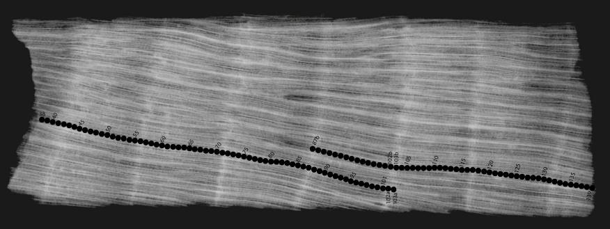
It all starts with taking X-ray images. These images reveal the internal structure of the coral skeletons, much like an X-ray can reveal the human skeleton. These scans tell a lot about the inner part of the coral, like how quickly it grows, and other useful information, like which direction the coral has grown in. This lets Diana find the best sampling path! It is very important to plan the sampling paths carefully, as in coral species with large polyps such as Orbicella faveolata, the time of formation of the edge of a polyp (the circular structures visible on the skeleton) may differ from the time of formation of the centre of a polyp. This means that the water temperature experienced by the individual skeletal elements may differ, and mixing would mean our reconstructions are wrong. You can see Diana’s carefully planned tracks in the image!
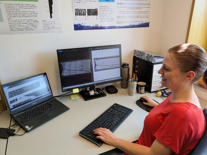
After thoughtful planning, Diana and her student assistant carried out the sampling with a computer-controlled drill capable of operating with micrometre precision, down to just 1 µm. The drill follows the exact sample path, so Diana can be sure her samples are in the right zone. In total, they collected over 3,000 samples.
But how does the coral skeleton translate into climate data?
These 3,000 samples had to be split into two subsamples so that the stable isotopes and trace elements could be measured. You may have read some of our previous blogs, and may know that stable isotopes and trace elements in coral skeletons are related to the sea surface temperature and the hydrology of locations. In Diana’s project, these measurements were taken at the Goethe University and the GEOMAR in Kiel.
In Diana’s project, she has analysed four coral colonies and generated sea surface temperature and hydrology reconstructions at monthly resolution, extending all the way back to 1815 CE.
What do the coral records tell us about the climate?
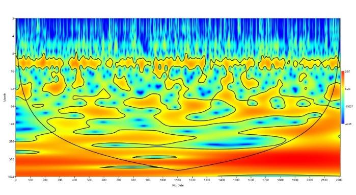
There are numerous tools that Diana is using to determine how climate variability has influenced her site in Belize since 1815 CE. One method she is using is called a continuous wavelet transform to detect changes in periodicity; you can see an example of this method below! Basically, a continuous wavelet transform is like a musical score for climate data—it shows not just what rhythms and cycles exist (like seasonal patterns or El Niño events), but exactly when they get stronger or weaker over decades or centuries. This technique has shown Diana that in her location, there is some relationship between the climate of the region and ENSO!
Want to see more behind the scenes, or read about Diana’s work?
Check out the Instagram page @Climatereefs for a behind-the-scenes look at what coral climate research really looks like and see some more images from Diana’s project. You’ll find videos from field trips, insights into how coral cores are collected and analysed, and explanations about how corals record climate signals. The page also features updates on ongoing projects, lab work, and life as an early-career climate researcher. Whether you’re curious about coral geochemistry, fascinated by tropical environments like Belize, or just want to know what climate science looks like in action, there’s plenty to explore.